Friday, August 30, 2019

Aug 29th, B group hikes Mt. Major

Five hikers set out to take in the beauty of the lakes region and the very popular, Mt. Major.  We had a wonderful hike up Belknap Ridge Trail (Blue blazes), to the summit of Mt. Major, then over to Straightback Mtn. 

From there we followed the Quary Spur trail (white blazes) over to the North Peak (no view there), and then back to the car via the Straightback link (green blazes) and on to the Brook Trail (yellow blazes).  I seem to remember orange blazes in there somewhere, but my notes don't capture it.  I'll have to follow up on that... but here's a snap shot of the route FYI.


Wednesday, August 28, 2019

The Bonds - First Group - August 26, 2019

Four of the OTHH did the exhausting 20-mile north-to-south traverse of the Pemigewasset Wilderness, on a beautiful, sunny, totally clear and dry day. We met at the Lincoln Woods trailhead on the Kancamagus Highway at 5:50 am (John wants all to know that, despite his well-known preference for later hike starts, he had indeed left home by 4:30 am to make the meetup time). We took one car back to 93, up the notch, and around to the end of Zealand Rd off rte 302. The trek got under way at 6:37; an early start was needed, as experience taught us that we probably would take all of the 12-hour "book time" to complete the hike, perhaps more, and sunset would come at 7:35 pm. It was 45 F, making for a very cool start, but without wind, the sun and brisk walking quickly warmed things up.

The easy first three miles took us in to the Zealand Falls AMC hut, with little more than 600 ft of elevation gain. The next 1.3 miles took us up another 1070 ft, to the Zeacliff outlook, with it's great views of the west side of the Tom-Field-Willey range across Zealand Notch and southward down to Mt Carrigain. Further westward along the Twinway trail, we took the short side trail to the viewless summit of Mt Zealand, then continued onward to the barren summit of Mt Guyot (elev 4560 or 4580 ft) and the northern end of the Bondcliff trail. Below is the view  southward from Guyot, with West Bond in the center and the long slope up to Bond on the left.

Moving south along the Bondcliff trail, we dropped our packs at the start of the half mile side trail up to West Bond. Below is Pam on top, with Bondcliff in the background.

After retreating and picking up our packs, we continued on up to Mt Bond, about ten miles and halfway through our hike. A pair of hikers came along at the right time to get the picture below, of Pam, Dick, Sandy (her 21st trek to the Bonds), and John. In the background is the east side of the Franconia Ridge, with the long Owls Head ridge to this side of it.

Then it was down and over to Bondcliff, yet another 1.2 miles to the south, and the fifth peak of the day. Below is a shot of all but the top of Bondcliff, from part way down from Bond; the path the trail follows along the rocks is seen easily, even a trio of hikers. The views on this hike were never ending.

Finally, atop Bondcliff, the last bit of uphill was behind us. Below is a shot of Pam close to the edge of the famous rock where many hikers like to stand for their own personal memoir of that peak. West Bond is behind her.

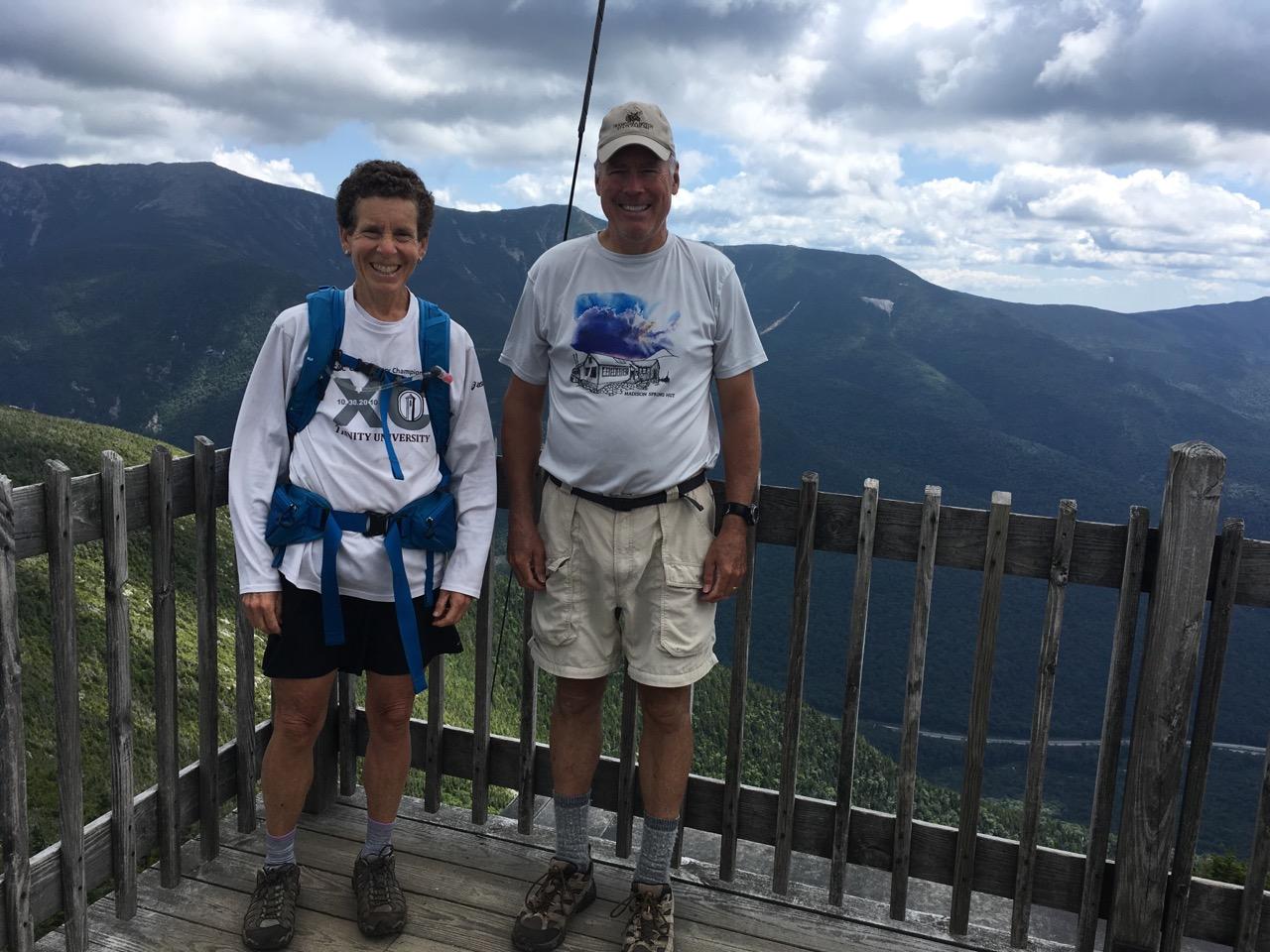
Now it was time to go home, so to speak. But that meant nine more miles. Below is a shot of John, not far from the top, halfway down what some have dubbed the "Hillary Step," a reference to a larger feature near the top of Mt Everest.

Then it was four more miles of fairly decent downhill trail through the woods to the junction with what had been called the Wilderness Trail years ago, an old logging railroad bed. We already were exhausted, having come 15 miles over five peaks, and it was nearly six pm. The next two miles to the bridge over the Franconia Brook, and the final three miles to the cars at the Kanc, were a grueling, "running on fumes" ordeal. If we'd had the energy to do much thinking, we might have recalled the lines from Robert Frost's famous poem: "The woods are lovely, dark, and deep. But I have promises to keep, and miles to go before I sleep." We came out just after sunset, a little over 13 hours after the hike began. Book time was only 12 hours, but, hey, we'll take it and be glad to be able to do this at all, considering three of us range in ages from 74 to 77. For John, it marked peaks 45, 46, and 47 of his "over 75" round, and the same for Dick's fifth round.

Turtles hike to Red Hill, Aug 27th


GROUP PHOTO TIME!

Aug 28th, we gathered on the steps of Mead Base Conservation Center for a group photo and interview with editor, Erin Plumber, Meredith News.

Erin plans to print an article in the Meredith News, next week, September 5th, in celebration of our 40th year anniversary!

I hope to add her photo to our blog, so please check back.

Groups of hikers and walkers alike took advantage of the beautiful day and set out on a trail of their choice: Mt. Israel, Beede Falls, or along the Bear Camp River Trail.
The view from Israel


Saturday, August 24, 2019

Hut Hike to Madison & Adams August 21 & 22

Severe thunderstorms all day!! Or so the forecast said. All of the weather forecast sites that hikers visit to check out the weather showed heavy rain for most of Wednesday with clearing Thursday morning. This caused many of the hikers to change their plans and not go hiking.

However, Larry and Doug decided to go and started at 7:30 from Appalachia. We arrived at Madison Hut around 10:30 to high overcast skies. All of the summits were clearly visible. After waiting a couple of hours to see how the weather would be, Larry and Doug then hiked the 0.5 mile trail to the summit of Mt Madison. The views were pretty good. We could see all of the Wildcats, Carters and Moriah to the east. The northern Presidentials and some of the southerns were visible. Many of the peaks to the west were visible so it was worth the effort. We descended back to the hut just as light rain started to fall around 2. The rain became heavier during the afternoon but ended by 7. It was surprising to see how many hikers went out into the rain to go on to their destination.

The hut was just about full that night and the food was okay. Doug really liked the chocolate chip cookies.

It was foggy Thursday morning but the forecast called for clearing by mid morning. The forecast was correct this time as the fog lifted by 9. Pam hiked up Thursday morning from Appalachia so she could get in Madison before we all headed to Adams. Views, again, were terrific. As we were headed down, it did rain for about 30 minutes.

This was a good warm up for the Bonds hike next week.

Below are Doug and Larry at the Madison Spring Hut on Wednesday.


We are happy because it is raining outside and we are inside.


Below is a view toward the John Quincy Adams summit from the hut. The highest Adams summit is behind this.


Below is Larry on the summit of Adams with Washington in the background.


Below are Doug and Pam on the summit of Adams.


Thursday, August 22, 2019

Turtles hike Whiteface and Piper (in the Belknaps), Aug 20th, 2019

Eleven hikers enjoyed a perfect day for a hike!  Special thanks to Betty for assisting a fellow hiker!


Wednesday, August 21, 2019

Mt Carrigain - August 20, 2019

Seven of the A group hiked up Mt Carrigain on a sunny, dry, 70s kind of day. Pictured atop the observation tower are Larry, Dick, Phil, Ann, Pam, Doug, and Tom.


Friday, August 16, 2019

B group hikes Hedgehog, Aug 15th


Today was a beautiful hike up Hedgehog.  The signs mislead us to follow the xc country ski trails way too long.  A few doubters tried to convince the other half of the group, but we all came to the realization of the mistake soon enough.  Thankfully the great views compensated for the mis guidance.  It was a wonderful hike with varied terrain.


Thursday, August 15, 2019

"A" Hike August 14/15 Lafayette & Lincoln

On Wednesday, three of the “A” hikers climbed Lafayette, Lincoln, and Little Haystack. It was a
beautiful day with temps in the 70’s and a light breeze and low humidity. We ascended Lafayette first and then traversed over the Franconia Ridge Trail to Lincoln and Little Haystack and then descended Falling Waters Trail that went by some beautiful waterfalls.

The views were jaw dropping throughout the hike and especially on Franconia Ridge. There was a lot
of traffic throughout the hike, but, because everyone was very friendly, it did not detract from the hike.

Because Franconia Ridge is on the AT we came across many through hikers. We chatted with one
couple who started the hike back in April and they had another 400 or so miles left. They did not look like they had been hiking for 4 months. They did say that the White Mountains have been the most difficult so far in their trek.


It was a great day for all. We are so lucky to have all these many mountains in our backyard to play in.


Several of the OTHH did the Lafayette/Lincoln/Little Haystack loop on the Franconia Ridge, on a great weather day. Evidently many others thought so, too, as there were a great many on the trail and summits. Below are Dick, Ginger, and Pamela atop Lincoln.


Well down the Falling Waters trail, there are several very nice waterfalls, like the one shown below.


Larry and Doug hiked the same route on Thursday August 15. The weather and views were great. You can see so much of the Whites while hiking along the ridge. We noted: Starr King, Waumbek, Adams, Jefferson, Clay, Washington, Monroe, most of the southern Presidentials but the clouds were casting shadows on the peaks so it was difficult to pick them out, Field, Willey, Kearsarge North, the Twins, Galehead, Guyot, West Bond, Bond, Bondcliff, Owl's Head, Carrigain, Garfield, Liberty, Flume, Cannon, the Kinsmans, Moosilauke, the Osceolas, Tecumseh, the Tripyramids, Passaconaway and Chocorua. As usual, we could see Killington, Pico, Camel's Hump and Mansfield in Vermont.


Wednesday, August 14, 2019

August 12 Cannon

Pam and Doug hiked the Kinsman Ridge Trail up Cannon on Monday. The trail starts near the base of the tram and goes up the face to the left of the tram. The trail heads toward the east shoulder of Cannon which provides some nice views into the valley. The trail also weaves in and out of the Kinsman Glade ski trail.

From the summit of Cannon, the views include Moosilauke, the two Kinsmans, Waumbek, Garfield, all of the Franconia Ridge, the two Osceolas. The Franconia Ridge blocks the view to the east.

Below are Pam and Doug at the summit and on the shoulder.


Monday, August 12, 2019

40th Year Celebration at HOBBS Tavern


-->

Turtles hike Black Cap, Aug 6th

Here’s an informal picture of us at the top of Black Cap on August 6th. 

Thursday, August 8, 2019

"A" Hike August 5 Owl's Head

Five of the A group (Doug, Larry, Pamela, Dick, and Frank) made the long 7 or 8 mile trek into the Pemigewasset Wilderness, then a very steep mile up the steep rock slide and "trail" through the trees on the west side of Owls Head, and finally a few tenths of a mile north along the ridge to the true summit. Below are pics of Dick at the small summit cairn and of the east side of the Franconia Ridge a thousand feet higher, a view the tourists can't see at all. Then it was back down that treacherous slide. The long trek back to the cars was relatively easy walking compared to that slide.


Below are Pam and Doug at the impressive Owl's Head summit cairn.


Below is Doug descending from the summit.


Tuesday, August 6, 2019

Turtles hike Little Sugarloaf

It was a great hike with views of Newfound Land on July 30th.


Thursday, August 1, 2019

Growing pains

As we celebrate the 40th anniversary of the Over the Hill Hikers, we are certainly experiencing changing times and some growing pains.  The internet and our excellent networking abilities have led to some serious growth among mostly our Turtles and B group hikes.  This has become problematic for several reasons; First, the White Mountain National Forest has a policy limiting group size to 10 hikers.  In addition, some of our trail heads have limited parking. And lastly, leading a group over 10 is exceeding the comfort of many of our volunteer "leaders / organizers".  

While there is no easy solution for us, and it is one that we collectively are struggling with, it is time that we may need to establish a hiking group size limit, or, designate an additional leader and divide into multiple groups for the scheduled hike with staggered start times (this may cause logistical problems).  

Please bear with us as we work through this and figure out the best way to handle our growing pains.  While we work to be good stewards of the WMNF policy, we may have to send our regrets to your interest in participating in a hike.  Please know that it is difficult for us as "leaders / coordinators", as our group has been one of inclusion and friendships.  I know it is hard as a “leader / organizer” to turn anyone away... but it may be necessary in order to comply with the policy of the WMNF and have a safe and enjoyable hike for all.

In addition to this difficult topic, I would like to add a few friendly reminders: 

            It is important to the enjoyment of your fellow hikers that you correctly choose the hiking level based on your CURRENT health, fitness, and endurance.  If you are unsure of your hiking level, it is polite to err on the conservative side and start with hikes where you have a high confidence level in your ability. 

And lastly, please ensure you have your emergency contact sheet in your pack, and the hiking essentials. I also recommend purchasing a HIKE SAFE Card for a modest $25.00 individual / $35.00 family.

Aug 1st, 2019, B group hikes South Moat

Several hikers took to the most amazing views of South Moat.  Many of us had never hiked this mountain, and it did not disappoint!  The views were  impressive, 360 degrees!  While the hike is challenging, the ledges were not as open as "Welch -Dickey", but the views were just as grand. Definitely a hike to come back to, the fall might be a perfect time to do this one again.