Hello, everyone -
What hiking level am I?
- About Over The Hill Hikers
- What hiking level am I, and how do I get involved?
- Over the Hill Hikers Emergency Contact Sheet
- Official 52 With A View List
- How to get a 52 WAV patch and FAQ's
- 2025 A Group / Difficult Hikes
- 2025 B Group / Moderate Hikes
- 2025 Turtles Hiking Schedule
- 2025 Friday Walkers Schedule
- Participant Liability Release
- 2025 Soup and Snowshoe
Monday, December 9, 2024
Friday, October 25, 2024
Wednesday, October 23, 2024
October 22, 2024 - Garfield
Five of us OTHH had a great late October day for the hike to the top of Mt Garfield. There was blue sky with bright sunshine, little wind, and fairly mild temperatures. The trail up is one that makes it fairly easy to beat "book time" by a lot. For the five miles and 3,000 ft of elevation gain, book time is four hours, but we did it in 3:10. Garfield offers great views of the "back side" of the Franconia Ridge, Owls Head, the Bonds, Twins, and Galehead. Below, at the top, are Pam, Marie, Dick, Michele, and Larry.
Friday, October 18, 2024
Monday, October 14, 2024
Sunday, October 13, 2024
Welch Dickey, Oct 10, 2024
The B group hiked Welch Dickey hoping to take advantage of beautiful views and fall colors. However, on this particular day, we decided to call the hike short and turn around prior to the summit as rain was moving in, and those slabs are certainly intimidating, if not dangerous in wet weather. So, it was a short hike, but any time in the woods is a success.
Saturday, October 5, 2024
October 3, 2024 - Lincoln and Lafayette
Fall is beautiful time of year for hikes with great views, and the A/B group hike on the Franconia Ridge is a prime example. We did the ever popular Falling Waters - ridge - Old Bridle Path loop. This is not a hike to do on a fall weekend (or even a summer weekend), as the crowds are huge. But midweek offseason is perfect for this, and since we all are "over the hill," we can do so. The views from the ridge are fabulous in all directions, from the western view down and across Franconia Notch to the eastern "hidden" side view into the Pemigewasset Wilderness. Below, the group appear a short way up the trail at a point where the two primary trails diverge. In front are Dick and Andrea; one row up has Pat, Katherine, and Jonathan; in the top row are Michele, Jane, and Steve.
Falling Waters is a good name for this trail, as the lower section has a number of falls. Here is but one.
The Falling Waters trail tops out at Little Haystack (elev. 4760'). From here, the trail runs along the ridge, over and up to Mt Lincoln (elev. 5089'). From there, the view northward, toward Mt Lafayette (elev. 5260') is shown below.
Mt Lincoln was a good spot for lunch. From there, the view southward shows the well-worn trail we traveled from Little Haystack. The two pointy peaks just beyond are Mt Flume (L), and Mt Liberty (R).
Finally, the ridge trail tops out at Mt Lafayette. Here we have Dick, Pat, and Andrea.
Thursday, October 3, 2024
Wednesday, October 2, 2024
Tuesday Sep 24 Madison & Adams
On Tuesday, 7 of us hiked to Madison (5366 feet) and Adams (5799 feet) while another hiked to Jefferson (5716 feet). Jane, Marie, Dick, Doug, John, Larry and Steve hiked to M&A. Pam hiked to Jefferson. Doug and Steve ascended some NH Terrifying 25 trails using King Ravine, the Subway and Great Gully on the way to Mt Adams. They then descended to the Madison Springs hut and over to Mt Madison. The rest of the group hiked up Valley Way to the hut, up and down Madison, then over to Adams, back down to the hut and then down Valley Way to Applachia.
Below is Mossy Falls which is along the King Ravine trail.
Below are Doug and Steve on the Adams summit.
Below is Doug descending from Madison into the clouds.
Below is Dick at the Adams summit.
Upon completion of this hike Larry finished his 5th round of the NH 48 4000 footers!! Congratulations to Larry for his achievement. We all enjoyed Pam's homemade carrot cake and bubbly.
Sunday, September 29, 2024
South Moat, Sep 27th
The B group hiked South Moat on the most gorgeous fall day. Nice breeze, warm temps and great trail conditions made this hike incredibly enjoyable.
Photo below, L to R: Tracy, Ginger, Nathaniel, Brenda, Katherine and Mary.Friday, September 20, 2024
Sep 19, Mt Moosilauke
The B group ventured out of the usual 52 WAV, and tackled Mt. Moosilauke for the win. It was a spectacular day, with warm temps and clear (but slightly hazy) skies. We even popped over to South Peak on the descent.
Wednesday, September 18, 2024
September 17 - Mt Moriah
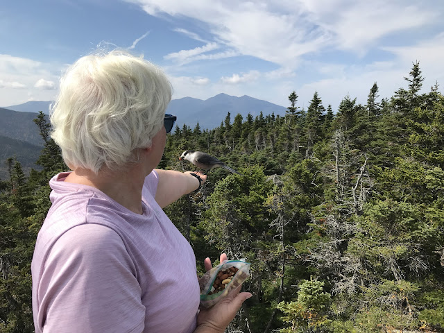
Michele and Dick hiked up the Carter-Moriah trail to the top of Mt Moriah on a clear, warm, not-quite-fall weather day. We saw all of four other hikers the whole day. The mid-section of the trail is noted for its many long stretches of somewhat steep rock slabs. But everything was dry, and the rough texture of the rock surface provided great traction, making both ascent and descent fairly easy. Below is Michele, at the top outlook rock, with one of several gray jays perched on her hand, lured by a treat from her goody bag. In the background are Madison, Adams, and Jefferson. Mt Washington is hidden by her head.
Sunday, September 15, 2024
Tuesday Sep 10 Monroe & Washington
Below is a view of what was supposed to be the summit of Washington from Monroe if someone wasn't in the way.
Thursday, September 12, 2024
Tuesday August 27 Wildcats
Three hikers made up the group hiking to Wildcat D (4062 feet) and Wildcat A (4422 feet). They were Pam, Pat and Dick. The group started at the base of the Wildcat ski area and used several ski trails to reach the Wildcat D summit. The ski trails and the tower at the summit offer excellent views of the east side of the northern Presidentials. The hikers continued on the Wildcat Ridge trail over to Wildcat A, the highest of the Wildcat peaks. This summit offers a great view of Carter Notch, Carter Dome and the summits to the east. The group then headed back on the same trails to the base of the ski area.
Below are Pam, Dick and Pat along the Wildcat Ridge trail.
Below is Pat on a Wildcat ski trail. In the background is Mt Washington with Tuckerman Ravine on the left and Huntington Ravine on the right.
Tuesday August 20 Isolation
Tuesday August 13 Owl's Head
There was a good sized group that hiked to Owl's Head. This hike is another long one, at 16 miles, to a summit that does not offer any view. There are a couple of short cuts that reduce the hike from 18 miles to 16 miles, so that helps. The group consisted of Ellen, her son Derrick, Jane, Marie, Michele, Patsy, Pam, Bob, Dick, Doug, Steve and Wharton. The hike started at Lincoln Woods off Rt 112, just east of the Loon ski area. The group hiked along the Lincoln Woods, Black Pond, Lincoln Brook trails and the Owl's Head path to the Owl's Head summit (4025). We then retraced our steps back to Lincoln Woods. There were several river crossings that provided varying degrees of challenge to get across.
Below are Jane, Katherine, Patsy, Michele and Wharton on the way to Owl's Head.
Below are Pam, Bob, Doug, Wharton and Steve at the Owl's Head summit. It was quite cool there.
Tuesday August 6 Zealand Bonds Traverse
This is one of the long hikes to summit four 4000 foot peaks. It's the Zealand Bonds Traverse, 19.7 miles long with about 3800 feet of elevation gain. Pam, Doug and Steve hiked this on a day with glorious weather and tremendous views along the way. The trio started at the Zealand trailhead off Rt 302 and used the Zealand trail and the Twinway to arrive at the Zealand Falls hut. They continued on the Twinway, taking a short side trail to enjoy the view from Zeacliff, and the Zealand spur to the summit of Zealand (4250 feet) and then back on the Twinway and over Mt Guyot. The summit of Guyot is treeless and offers some nice views as well. Just beyond Guyot, the group continues hiking on the Bondcliff trail. This leads to a 0.5 mile spur to West Bond (4540 feet). The trio continued on the Bondcliff trail over Bond (4698 feet) and Bondcliff (4265 feet). Most of the way from Bond to Bondcliff is treeless so the view is very nice. There was also a nice refreshing breeze. Leaving Bondcliff, it is a 9 mile descent, half of which is very flat, all the way to Lincoln Woods on Rt 112.
We want to thank Katherine for the taxi service and snacks that morning. She transported us from Lincoln Woods to the Zealand trailhead. This allowed us to head straight home after a long hike instead of having to drive back to Zealand and then head home.
Below is a view toward Carrigain from Zeacliff.
Wildlife (Grouse) along the way.
A view of Bondcliff from West Bond.
Approaching Bondcliff.
On Bondcliff!
July 8 - Liberty & Flume
Weather and summer activities often have resulted in reduced "A" group hike participation. Pat and Dick comprised the entire "group" on the hike up to Mt Liberty, over to Mt Flume, and then back to Liberty and down. Below is Pat, as we approached the top of Mt Liberty.
Tuesday July 30 Waumbek
In addition to the Tripyramids hike, two hikers climbed Waumbek. Leanne and Marie started at the Starr King trailhead in Jefferson. They ascend on the Starr King trail to the Starr King summit (3907 feet), which is on the 52 With a View list. They then continued to the Waumbek summit (4006 feet).
It was foggy there, too.


